We could not find any results for:
Make sure your spelling is correct or try broadening your search.
| Share Name | Share Symbol | Market | Type |
|---|---|---|---|
| Trillium Gold Mines Inc | TSXV:TGM | TSX Venture | Common Stock |
| Price Change | % Change | Share Price | Bid Price | Offer Price | High Price | Low Price | Open Price | Shares Traded | Last Trade | |
|---|---|---|---|---|---|---|---|---|---|---|
| 0.00 | 0.00% | 0.07 | 0.065 | 0.08 | 0 | 00:00:00 |
VANCOUVER, BC, July 26, 2021 /CNW/ - Trillium Gold Mines Inc. (TSXV: TGM) (OTCQX: TGLDF) (FRA: 0702) ("Trillium Gold" or the "Company") is pleased to report the results from the first two drill holes at the Gold Centre Project in Red Lake, Ontario. The Gold Centre property consists of one lease of 16 contiguous historical mineral claims encompassing 253 hectares, immediately adjacent to Evolution Mining's Red Lake Operations (EVN-RLO).
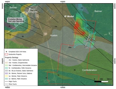
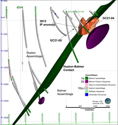
These initial drill holes (GC21-04 and GC21-05) were drilled on section and parallel to each other targeting the interpreted Huston-Balmer assemblage contact and the eastern margins of an interpreted induced polarization (IP) anomaly (see Figures 1 & 3).
"Our first two drillholes at the Gold Centre property already indicate a very favourable milestone. We have seen both the source of the IP anomalies and the Huston-Balmer contact as well as indications of the same alteration and structures as at the Red Lake Mine next door," states William Paterson, Trillium Gold's Vice President of Exploration. "With access to the western side of the property now becoming a possibility, we anticipate even more success in the drilling".
Trillium's 2021 drill program is focused on the north end of the property, comprising approximately 8,000 metres in 8 drill holes, targeting Red Lake Mine stratigraphy and anomalous trends identified in the 2013 induced polarization survey. These anomalies are interpreted to be indicative of a sulphide mineralization source, potentially associated with a complexly folded/faulted contact between the overlying Huston sediments and Balmer mafic metavolcanic rocks. This appears to be coincident with the southeasterly extension of a regional scale fault mapped on the EVN-RLO property. The proximity of the Far East Zone at the EVN-RLO provides further support that the southwest-dipping and southeast plunging Red Lake Mine trend potentially extends onto the Gold Centre property along strike and at depth.
The rock types, structures, veining, and alteration (specifically the brown biotite) within the Balmer assemblage rocks show strong correlation with those observed at the Red Lake Mine immediately to the west-northwest. Detailed analysis of oriented core shows a consistent D2 foliation parallel to the Huston-Balmer contact. A conjugate set of carbonate +/- quartz veining is indicated both parallel and oblique to the contact and late (post foliation) fractures and faults perpendicular to the veining and foliation. These north to northeast trending structures have been observed to cut and offset both the Huston-Balmer contact and the IP anomaly.

Figure 1: Plan of Gold Centre drill holes reported in this press release with geology and targeted IP anomalies. Base geology and legend from Sanborne-Barrie 2004 (GSC-OF4594).
Preliminary interpretation of drill hole data suggests that the IP anomalies targeted in holes GC21-04 and GC21-05 are most likely due to sulphide mineralization intersected at the Huston-Balmer contact. As drilling progresses to the northwest stratigraphically, this mineralization is expected to become more intense in concert with the intensifying anomaly to the west-northwest. Two styles of mineralization have been observed; 1) foliation and lithological hosted pyrrhotite, pyrite, magnetite, trace chalcopyrite; and 2) fault-fracture hosted pyrite +/- pyrrhotite.
Drill hole GC21-04 was drilled to a total depth of 830m, intersecting the target contact at 521.1m. The Huston Assemblage rocks comprised interbedded argillites, sandstones, polymictic conglomerates and greywackes with minor intrusive quartz feldspar porphyry (QFP) and intermediate to mafic dykes to a depth of 521.1 m. Immediately above the contact, strongly to intensely fractured sandstones with strong sericite – silica alteration and trace to 3% fracture fill pyrite mineralization was intersected from 516.5 m to 521.1m.
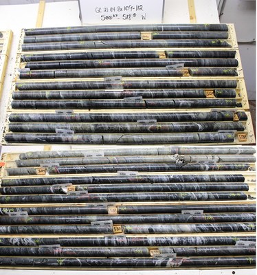
Below the contact, the Balmer assemblage comprised predominantly of massive (locally pillowed), mafic volcanic flows and volcaniclastic rocks with weak to moderate chlorite, brown biotite, and occasionally sericite alteration throughout. At the Huston-Balmer contact, the mafic volcanic flows exhibited strong (up to 30% locally) <5 cm carbonate +/- quartz veining, with 2-3% sulphides overall, locally containing 5-10% pyrrhotite/pyrite mineralization hosted as fracture filling, fine-grained disseminations and within quartz-carbonate veins (see Figure 2).
Two narrow QFP dykes were intersected in the Balmer stratigraphy near the contact. At the end of the hole, a gabbroic intrusion was encountered (Unit 2b), also seen in a deep historical hole.

Figure 2: Drill hole GC21-04 showing the Huston–Balmer contact at 521.1 m (labelled on core near middle of photo). Intense sericite alteration occurs in the Huston rocks, whereas intense carbonate veining/alteration occurring in the Balmer rocks helps distinguish the contact.
Collared southwest of GC21-04, drill hole GC21-05 was completed to a total depth of 809m, intersecting the target Huston-Balmer contact at 713.15m. The contact corresponds well to the interpreted down-dip projection from surface mapping and previous holes drilled on the property. A similar sequence of Huston assemblage sedimentary rocks with felsic and intermediate to mafic intrusive rocks was intersected in the hanging wall. A thick black argillite unit encountered at the Huston-Balmer contact exhibited minor shearing.
The Balmer aged rocks were noticeably similar to those intersected in GC21-04. In GC21-05, sulphide mineralization was generally restricted to trace to minor disseminated pyrite, pyrrhotite with trace chalcopyrite scattered throughout, up to 7%, and trace to minor chalcopyrite. Occasional short sections contain up to 5% coarsely disseminated magnetite in addition to the pyrrhotite. Quartz carbonate veining contained rare sulphides along contact margins and were consistent with amounts contained overall within the host lithology.
Core was selectively sampled in the Huston-age sedimentary units, based on alteration and mineralization observations. Core was sampled 100% through the contact zone and the Balmer lithologies. All assays are pending.

Figure 3: Section looking west (towards EVN-RLO) of Gold Centre drill holes reported in this press release (GC21-04 & -05), historical drill holes, modeled IP anomaly and Huston-Balmer contact.
Table 1: Drillhole location details for holes reported in the current press release.
Hole ID | Easting | Northing | Elev (m) | Length (m) | Dip | Az |
GC21-04 | 450890 | 5654710 | 365 | 830.36 | -65 | 015 |
GC21-05 | 450810 | 5654504 | 363 | 809.00 | -65 | 015 |
Previous drilling on the property was conducted from 2004 to 2008 by Rupert Resources (Rupert), focused on ultra-deep targets under the south end of the property, targeting Red Lake Mine mineralization at depths down to 3,400 metres.
All drilling work is supervised by Richard Kowalski, formerly the Project Manager for Rupert Resources' drill programs in 2004 to 2008. The drilling is being conducted by Rodren Drilling Ltd., of West St. Paul, Manitoba. Drill core is logged and sampled in a secure core facility and core samples are cut in half, using a diamond cutting saw, and half cores sent for analysis to Activation Laboratories Ltd. in Dryden, an accredited mineral analysis laboratory. All samples are analysed for gold using standard Fire Assay-AA techniques. Samples returning over 10.0 g/t gold are analyzed utilizing standard Fire Assay-Gravimetric methods. Selected samples with results greater than one ounce per ton gold are also analyzed with a standard 1kg metallic screen fire assay. Certified gold reference standards, blanks and duplicates are routinely inserted into the sample stream, as part of Trillium Gold's quality control/quality assurance program (QAQC) to monitor accuracy and precision. The technical information presented in this news release has been reviewed and approved by William Paterson QP, PGeo, VP of Exploration of Trillium Gold Mines., as defined by NI 43-101.
Visit our website at www.trilliumgold.com.
On behalf of the Board of Directors,
Trillium Gold Mines Inc.
"Russell Starr"
Russell Starr
President, CEO and Director
About Trillium Gold Mines Inc.
Trillium Gold Mines Inc. is a growth focused company engaged in the business of acquisition, exploration and development of mineral properties located in the Red Lake Mining District of Northern Ontario. The Company recently increased its holdings in the Confederation Lake and Birch-Uchi greenstone belts and has a non-binding LOI to further consolidate its contiguous land assemblage to more than 100 km in length. In addition, the Company has interests in highly prospective properties in Larder Lake, Ontario and the Matagami and Chibougamou areas of Quebec.
Neither TSX Venture Exchange nor its Regulation Services Provider (as that term is defined in the policies of the TSX Venture Exchange) accepts responsibility for the adequacy or accuracy of this release.
This news release contains forward-looking information, which involves known and unknown risks, uncertainties and other factors that may cause actual events to differ materially from current expectation. Readers are cautioned not to place undue reliance on these forward-looking statements, which speak only as of the date of this press release. The Company disclaims any intention or obligation, except to the extent required by law, to update or revise any forward-looking statements, whether as a result of new information, future events or otherwise.
![]() View original content to download multimedia:https://www.prnewswire.com/news-releases/trillium-gold-encounters-red-lake-mine-associated-stratigraphy-at-initial-gold-centre-drilling-301340885.html
View original content to download multimedia:https://www.prnewswire.com/news-releases/trillium-gold-encounters-red-lake-mine-associated-stratigraphy-at-initial-gold-centre-drilling-301340885.html
SOURCE Trillium Gold Mines Inc.

Copyright 2021 Canada NewsWire
1 Year Trillium Gold Mines Chart |
1 Month Trillium Gold Mines Chart |

It looks like you are not logged in. Click the button below to log in and keep track of your recent history.
Support: +44 (0) 203 8794 460 | support@advfn.com
By accessing the services available at ADVFN you are agreeing to be bound by ADVFN's Terms & Conditions