We could not find any results for:
Make sure your spelling is correct or try broadening your search.
| Share Name | Share Symbol | Market | Type |
|---|---|---|---|
| Typhoon Exploration Inc | TSXV:TYP | TSX Venture | Common Stock |
| Price Change | % Change | Share Price | Bid Price | Offer Price | High Price | Low Price | Open Price | Shares Traded | Last Trade | |
|---|---|---|---|---|---|---|---|---|---|---|
| 0.00 | 0.00% | 0.045 | 0.04 | 0.045 | 0 | 00:00:00 |
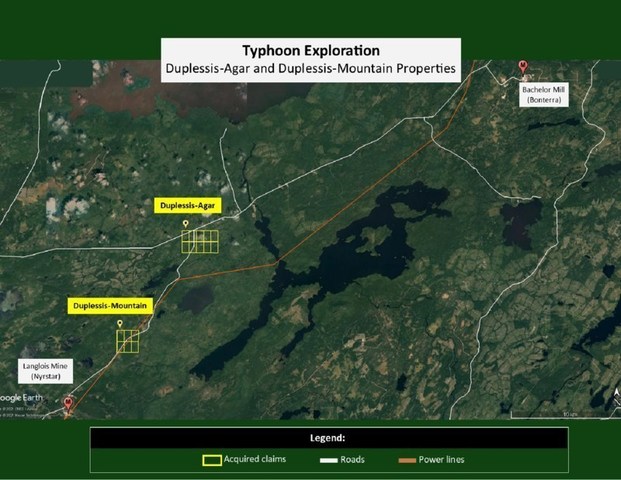
PIEDMONT, QC, July 27, 2021 /CNW Telbec/ - Typhoon Exploration Inc. (TSXV: TYP) ("Typhoon" or "the Company") is pleased to announce that it acquired, from Breakwater Resources, two gold properties – Duplessis–Agar and Duplessis–Mountain – located between 60 and 70 kilometres north-east from Lebel-sur-Quévillon (province of Quebec), and west of Pusticamica Lake (Nord-du-Québec Administrative Region).

Location
The transaction covers 16 mining claims separated into two distinct blocks (Duplessis– Agar and Duplessis–Mountain), and totalling nearly 900 hectares, which are easily accessible by regional roads and a network of forestry roads.
These claims are part of an important regional geological structure within the Urban–Barry mining camp, which is renowned for its gold potential and which holds at least 14 recognized gold deposits with historical or published resources1.
Duplessis–Agar
The gold showings of the Duplessis–Agar Property are located approximately 30 km south of the Bachelor Mine mill, currently in the Site Restoration and Environmental Study phase by the company Bonterra Resources Inc. (TSXV: BTR).
Since 1945, various exploration work (stripping, ground geophysics, drilling) has been carried out on the property. At the end of the 1980s, this work intensified and focused on the property's gold potential.
The gold system defined by historical work covers an area of approximately 0.5 by 1.0 km, where stripping has revealed no less than 8 zones of mineralized outcrops.
From 1945 to 1990, 111 holes, representing 15,320 metres to a maximum vertical depth of 250 metres, were drilled on the property2.
Results
The compilation of historical work has made it possible to identify a series of significant results, the grade of which generally varies between 2.5 g/t Au and 5.75 g/t Au, over lengths ranging from 2.5 m to more than 10 m.
The table below presents a series of historical results3 from the documented work carried out between 1988 and 1990.
Drill Hole Number | From (m) | To (m) | Grade (g/t Au) | Length (m) |
AG-88-24 | 121.00 | 130.5 | 2.80 | 9.50 |
AG-88-26 | 33.90 | 34.50 | 9.00 | 0.60 |
AG-89-02 | 89.89 | 92.51 | 5.75 | 2.62 |
AG-89-03 | 186.93 | 193.55 | 3.74 | 6.62 |
AG-89-10 | 158.85 | 169.13 | 2.60 | 10.28 |
AG-90-01 | 176.70 | 177.70 | 6.18 | 1.00 |
AG-90-10 | 204.75 | 205.25 | 14.55 | 0.50 |
Geology
The Agar mineralized system is hosted by a localized complex of mafic intrusions within a large regional north-east trending shear. The types of rocks that contain the gold mineralization are varied: diorite, gabbro, porphyritic intrusions, felsic volcanic rocks and sediments. The known structural orientations make it possible to infer the presence of a kilometric fold hinge.
The gold mineralization occurs in the form of silicification and pyritization zones, which, in certain places, host quartz veins. These zones have been intersected in different structures, over core lengths varying from a few metres (in the case of the best results) to more than 100 metres (in the case of mineralized halos).
Typhoon will proceed with the integration of all historical exploration data into a comprehensive database and construct a 3D exploration model. All targets generated by this compilation work will be drill tested. The Company is very excited to undertake this exploration effort on a property that has not seen any exploration work in over 30 years and that is strategically located in a very active mining camp.
"This new positioning in a very active exploration area is part of Typhoon's strategy to pursue the acquisition of high potential mineral properties, to increase the value of the Company, and increase shareholder value," states Ghislain Morin, Typhoon Exploration's CEO.
Typhoon acquired 100% of the Duplessis–Agar and Duplessis–Mountain properties for $125,000 cash and a 1% royalty (NSR).
_________________________________
1 | Source: Ministère de l'Énergie et des Ressources naturelles du Québec (sigeom.com). |
2 | Source: Ministère de l'Énergie et des Ressources naturelles du Québec (sigeom.com). |
3 | Report on the Diamond Drill Program – Agar Property, 1988, Minefinders Corporation Ltd; Report on Diamond Drilling – Agar Property, Winter 1989-1990, Minefinders Corporation Ltd; Report on Diamond Drilling – Agar Property, Fall 1990, Malartic Hygrade Gold Mines (Canada) Ltd. |
The TSX Venture Exchange and its regulatory service provider (as defined by the TSX Venture Exchange rules) cannot be held responsible for the accuracy or veracity of this press release.
SOURCE Typhoon Exploration Inc.

Copyright 2021 Canada NewsWire
1 Year Typhoon Exploration Chart |
1 Month Typhoon Exploration Chart |

It looks like you are not logged in. Click the button below to log in and keep track of your recent history.
Support: +44 (0) 203 8794 460 | support@advfn.com
By accessing the services available at ADVFN you are agreeing to be bound by ADVFN's Terms & Conditions